The ambition of the project Urban Algae Folly 2.0 is to use the artistic dimension of architecture as a mean to interface technical, technological and scientific research with society's future needs and sustainable values.
For this reason we are engaging with urban public spaces as open air Laboratories. Public piazzas have been historically the core arenas of democracy, of public engagement and participation. The places where the core values of our society where shaped and are still being shaped today. In this project the participation of the public is vital to evolve the methods and protocols of what we call "collective urban cultivation". Such methods have as main purpose to promote art and architecture as tools to develop resilient and sustainable future urban plans.

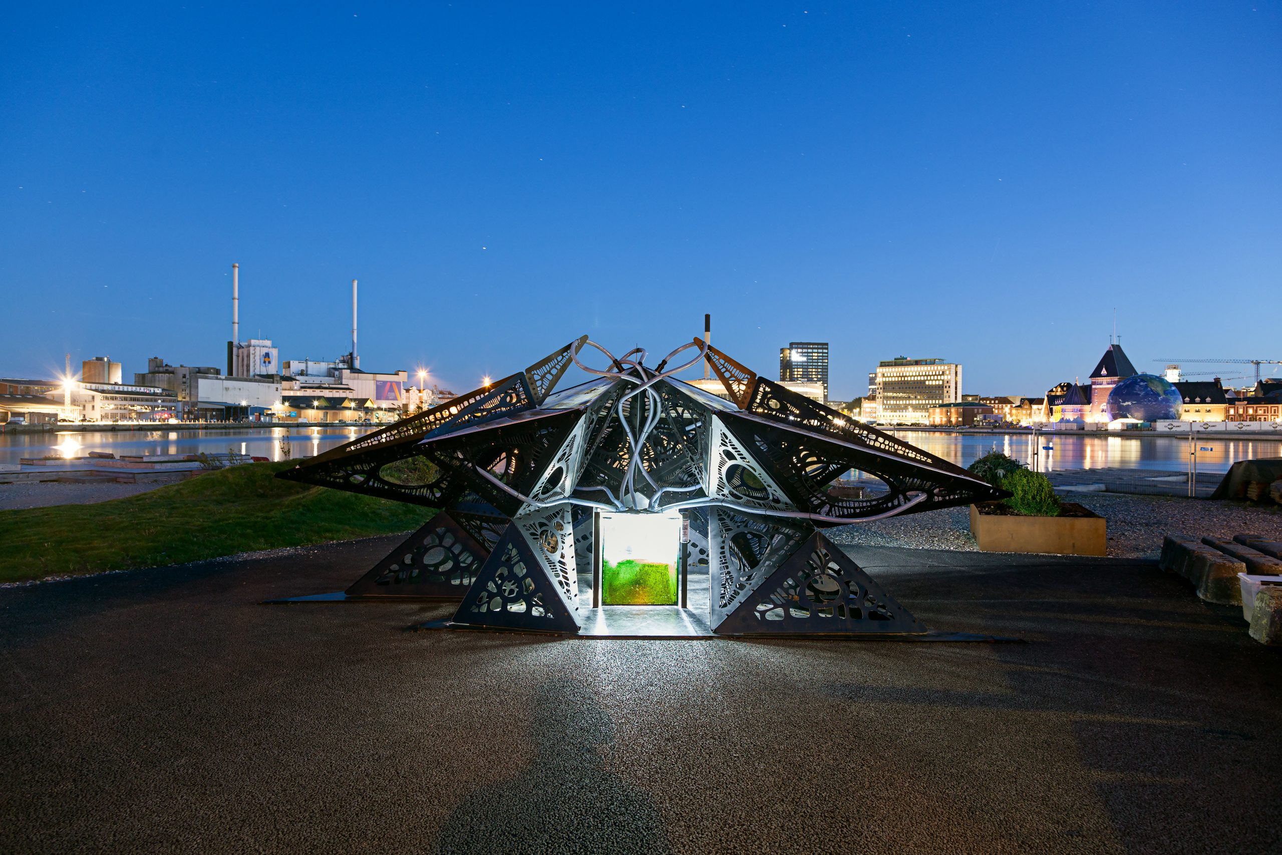
The Urban Algae Folly, hosts a total of 400l of living cultures. It absorbs 500 g of CO2 per day and produces 375 g of O2. Its ability to absorb CO2 is equivalent to that of 8 large trees which is the amount of trees per year to cover the O2 needs of a person. Its yearly protein production is 102 kg which is equivalent to the protein meat of a small cow. UAF can produce 168g of oil per day from which approximately 250 g of biofuel can be produced, releasing up to 10 MJ of energy or 2.6 KWh. That is enough to power an eco-home in Denmark.
- O2: 137 kg/Year
- CO2: 183 kg/Year
- Protein: 102 kg/Year
- Biofuel: 91 kg/Year
- Energy: 949 KWh/Year


The exceptional properties of microalgae organisms [Chlorella vulgaris in this case] are enhanced by their cultivation within a custom designed soft ETFE cladding system. This represents a radically new interpretation of the possibilities of the ETFE cladding. A special CNC welding technology is at the core of it and enables ecoLogicStudio to design and control the morphology of the cushions under stress as well as the fluid dynamic behaviour of the nutritious medium as it travels through it.


The flows of solar energy, water and oxygen are regulated to respond and adjust to weather patterns and visitor's movements in real-time. As the sun shines algae would photosynthesise and grow thus reducing the transparency of the Folly and changing its appearance; since this process is driven by the biology of micro-algae is inherently responsive and adaptive; visitors will benefit from this natural shading property while being able to influence it in real-time; their presence will trigger electro valves to alter the speed of algal flow through the folly provoking an emergent differentiation across the space. In any moment in time the actual transparency and colour of the folly will be the product of this complex set of relationships among climate, micro-algae, visitors and digital control systems.
As in the example of Aarhus, public involvement will be directly stimulated with the installation of the innovative Urban Algae Folly next to the Dome of Visions in the Aarhus' harbour, and then harvested with the proposal of a new Planning Interface designed to contribute to the development of the future blue-green plans of Aarhus. This new instruments channel the latest innovation in igital and bio-technology to the benefit of our urban environment and its future development.
The project proposes to collaboratively test the new application of digital and bio-technologies to the urban realm in the city of Aarhus; to achieve this goal a living, interactive architectural folly will be installed in Aarhus' harbour and work as an incubator of the microecologies present in the city's urban waterways; the piece will make such ecosystems visible to all and instigate visions of a future where microorganisms will contribute to the city's own expanded metabolism, by filtering urban wastewater, digesting organic waste, growing bio-fuels as well as super-food for humans and animals. At the same time a new urban planning interface is proposed to harvest the collective intelligence of the Aarhus' population in the crafting of the future blue-green plan of the city.

The Urban Algae Folly provides a focal point of attraction in the public realm and is designed to involve citizens in a tangible demonstration of what a future blue-green urban infrastructure may look like and how it may operate in a dynamic dialogue with the surrounding environment; the digital interface, called Aarhus Wet City, instead expands on the potential of this approach for the future planning of the city of Aarhus.
Blue - green ecosystems are networks, their life and proliferation determined by a large number of feedback loops that affect all the systems involved including manmade ones. A future resilient and sustainable blue-green masterplan must recognize these existent biological networks and enable manmade ones to be co-evolutionary of the former.Unfortunately traditional planning tools tend to rely on a typological segregation of functions that we have inherited from modernity and that act as an obstacles to such co-evolution.

So for instance we often refer to parks, green ways, fountains, ponds and so on as clearly defined and spatially demarcated types. But trees in a park, in reality, are a network, and so are their roots connected via biological / informational networks operated by mycelia. Such networks do not stop at the end of the park area but continue both above and below ground; insects, worms and other animals, as well as wind and rain, contribute to the resilience of these networks by providing alternative channels of communication for seeds, pollen, and so on. Architecture too can be used to expand these channels of communication. Digital technologies and satellite monitoring devices enable designers to map and draw every single tree in a city and their exact geographic location: in Aarhus there are for instance 141.765.
If we then run an algorithm that draws a line connecting all the trees that sit within a certain distance from each other we can explore the nature and morphology of these urban bio-networks. We can visualize urban parks as areas with a high degree of connectivity and conversely detect zones where the network has a poor level of connectivity and new plantings may be critical to increase its resilience by providing precious missing links.
Not only but such networks can be overlapped with topographical analysis and rain water flow patterns to see how water networks and trees networks spatially and physically interact. Foliage and roots systems are one of the most powerful tools we have to control and prevent flash flooding, erosion and other water related hazards. A strong and co-evolutionary blue and green infrastructure provides a resilient substratum for our cities to grow and thrive in the future. But how about the interaction between this substratum and the urban networks that we, humans, have built? Old infrastructures, like water, energy or cycling and other public and private transportation networks as well as new digital networks? We can include in our digital definition of the blue - green Aarhus an abstract version of the main road network of the city, where every junction is a node and every road or path a link. We can then map every single building as a dot, a starting or end node in the network of roads and paths.
A sensible planning guideline would suggest everyone of us should live in close proximity to nature and or cycle or walk along natural features on our way to work or back home.
Simulating this condition would mean running another algorithm to compute the shortest path from our home, workplace or restaurant to the closest tree or cluster of trees of a certain minimum density and size. This algorithm could run for every household in the city and create a map of overall proximity and interconnectivity of our manmade infrastructures and natural biological urban networks.
But since we are now living in the digital age nearly everyone of us is equipped with a device that connects us in a real-time to multiple social networks; the algorithms we described above can therefore run in real-time, triggered by direct citizens interaction with the urban environment. Let's imagine this scenario.


1 / 3
Like in a botanical garden every urban tree is now equipped with a QR code, a digital tag that enables every citizen with a smart phone to enquiry the tree in real time and read information about its location, specie, age, size and other management infos like when was it last pruned. Each citizen or visitor in Aarhus could then scan his favourite tree or cluster of trees and not only learn about their current status but also compute and load on the system the shortest paths from those trees and his / her home, workplace or favourite restaurant.
As more and more people would interact with the system a real-time map would begin to emerge, a network of paths whose thickness would show their level of favour among the population while their colour could indicate their length, that is the minimum distance between the favourite natural spots in Aarhus and people's homes location.
Of course as the map grows and patterns emerge new interventions can be planned and actuated in the spots where their impact would be more deeply felt. Like for instance planting of new trees along busiest paths with low natural connectivity and hi rain water runoff.
These interventions, coming from the municipality or from empowered local community groups, would alter the overall patterns of interaction and induce new behaviours in the population which in turn would feature in the evolving blue - green urban plan. Urban planning becomes an iterative process; its evolution the result of feedback loops of interaction between multiple and heterogeneous systems. The blue - green plan of Aarhus would evolve in time like the living systems that it describes and manages.


1 / 5
Minimal Path
The informatization of urban blue - green systems is one of the fastest emerging sectors in the smart city trend with companies like the Scandinavian Husqvarna at the fore front of the movement. However true progress is only possible when design and planning strategies and techniques also progress to take advantage and enable technological innovation towards a participatory framework.
We believe that smartness without participation only leads to fragile and control obsessive regimes; the project Aarhus Wet City and the Urban Algae Folly are a demonstration and a test bed of how bio-digital technologies can be deployed in a truly participatory framework to enable the emergence of a new breed of sustainable urban design strategies and planning.


1 / 6